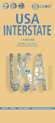
Borch Map USA Interstate - USA (West), USA (East), Puerto Rico, Hawaii, Alaska, Vereinigte Staaten von Amerika. Markier- und abwischbar
Reduzierte Artikel in dieser Kategorie

3,99 €
8,99 €
| Verlag | Borch |
| Auflage | 2025 |
| Umfang | 2 Seiten |
| Format | 11,2 x 1,1 x 24,6 cm |
| Mehrfarbendruck. Gefalzt | |
| Gewicht | 111 g |
| Artikeltyp | Karte |
| Reihe | Borch Map |
| ISBN-10 | 3866093675 |
| EAN | 9783866093676 |
| Bestell-Nr | 86609367A |
Our laminated and folded Borch Map of the United States of America, USA Interstate, in the 19th edition contains: USA West 1:4 000 000, USA East 1:4 000 000, Puerto Rico 1:4 000 000, the Southeastern Hawaiian Islands 1:4 000 000, Alaska 1:8 000 000 and an administrative map of the USA with time zones. Borch Maps contain a multitude of interesting and useful information, highly detailed and user-friendly cartography, but also statistics, conversion tables, climate data and numerous detail maps, making a Borch Map an excellent travel companion. Map format (open): 990 x 685 mm.
Unsere folienbeschichtete und gefaltete Borch Map der Vereinigten Staten von Amerika, USA Interstate, in der 19. Auflage beinhaltet: USA West 1:4 000 000, USA Ost 1:4 000 000, Puerto Rico 1:4 000 000, die südöstliche Inselkette von Hawaii 1:4 000 000, Alaska 1:8 000 000 und eine administrative Übersichtskarte der USA mit Zeitzonen. Borch Maps beinhalten eine Vielzahl interessanter und nützlicher Informationen, detailreiche und benutzerfreundliche Kartographie, aber auch Statistiken, Umrechnungstabellen, Klimadiagramme und zahlreiche Übersichtskarten, die eine Borch Map zu einem exzellenten Reisebegleiter machen. Kartenformat (offen): 990 x 685 mm.
